As a high-density, coastal city, New York is extremely vulnerable to the impacts of climate change. This is especially true for many residents of its outer boroughs, where social, economic and equity factors may compound climate-related risks.
Though the City is investing in capital projects to improve resiliency, they require significant time and money. It’s unlikely that these projects alone will protect New York’s 500+ miles of shoreline.
HOK’s team has been exploring how long-term planning and an integrated approach to addressing climate change can create resilient places and new opportunities for a population that will need to migrate away from a shifting coastline.
The Water Is Coming: What Now?
Cities including New York, Boston, Miami and many others are already exploring the ability of floodwalls and floodgates to protect them against rising sea levels and more powerful storms. But these systems have several limitations. In the near term, they come with hefty price tags and may only offer protection for a limited portion of a city. In the long term, they can cause major disruptions to ecosystems and could be breached as sea levels continue to rise.
For New York, current projections from the New York City Panel on Climate Change assume six feet of sea level rise by 2100. The City is investing over $900 million in capital projects to protect less than six miles of shoreline in Lower Manhattan. Yet in a city with 520 miles of coastline, a six-foot sea level rise would put 40 percent of Brooklyn and 33 percent of Queens at risk of a major flood.
Our NYC 2100 project provides a more holistic approach to mitigating climate change risks. We mapped out areas most vulnerable to storm surges and floods, including risks to residential populations, healthcare facilities, critical infrastructure, transit stations and public parks. We also identified opportunities for new or enhanced transit-oriented development throughout the outer boroughs—outside the path of the rising waters.
New Opportunities for Transit-Oriented Development
We’re still learning exactly how climate change will impact New York. Yet we already know the city is experiencing an affordable housing crisis. As rising waters threaten existing housing stock, this housing crunch will only get tighter. To make matters worse, many of New York’s affordable neighborhoods are in high-risk flood areas.
Current trends indicate New York’s population will increase to 10 million by 2100. Yet city leaders must plan for internal migration as well as growth. About 1.4 million people currently reside in areas of the outer boroughs that are expected to be inundated with six feet of sea level rise by 2100. To accommodate a growing population and provide at-risk residents with new housing opportunities away from the shifting coast, New York will need to add 1 million residential units or 1 billion gross square feet of residential space, outside of flood-risk areas.
Our study envisions meeting this challenge through an incremental increase of the floor area ratio (FAR) to allow for denser development on underutilized land near public transit but outside the floodplain. By examining city data, we identified 7,200 acres of vacant, soft sites or non-manufacturing-zoned properties within a quarter mile of existing or proposed transit outside the projected flood risk in 2100.
Developing projects in urban areas around public transit improves access to jobs and opportunities, reduces the use of cars and their emissions, and creates walkable, lively and climate-resilient neighborhoods. Aggressively increasing mixed-use density, including a significant number of residential units within walking distance of transit, is a key strategy in mitigating barriers to affordability and mobility.
To further refine this solution, we recommend careful study at the neighborhood-scale to create climate interventions that are unique to their surrounding context and balanced with transit access.
Denser Mixed-Use Neighborhoods
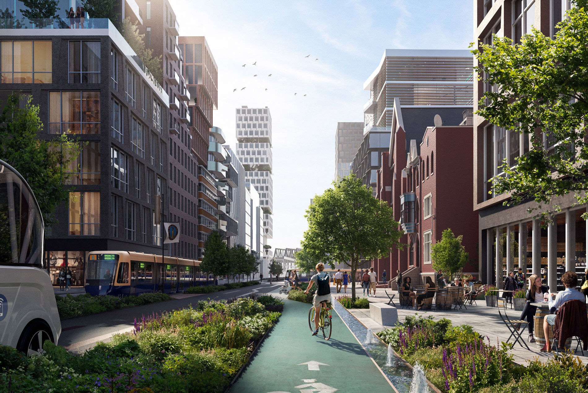
What would these new transit-oriented developments look like? For starters, we envision walkable, mixed-use neighborhoods in South Slope, Brooklyn, and the emerging commercial center of Jamaica Center, Queens.
In Brooklyn’s South Slope neighborhood, the 9th Street corridor could accommodate increased pedestrian areas with lush soft infrastructure in the rights-of-way. Denser mixed-use, residential development could provide more mixed-income housing close to transit stations. Active ground floors could be repurposed for civic, community and maker spaces, creating a lively, walkable streetscape that enhances the neighborhood’s quality of life. Bikeways and a trackless tram could create additional mobility options that augment subway and light rail.
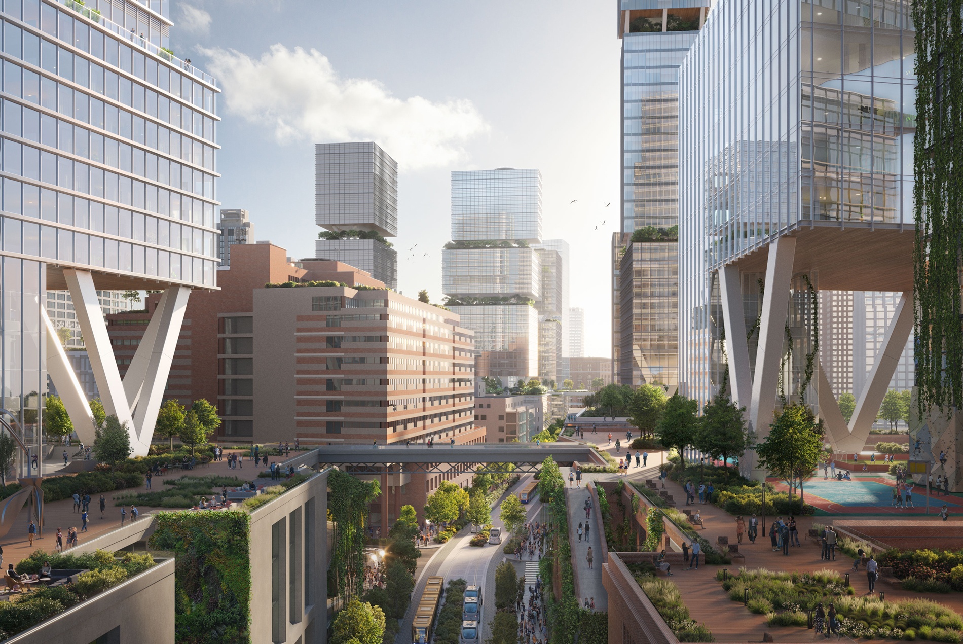
In the high-density, mixed-use, mixed-income neighborhood of Jamaica Center, Queens, reimagined ground floors could sit below commercial podiums providing office, institutional and civic uses, as well as maker spaces. At the 6th level, large recreational areas with densely planted landscapes could provide an elevated space for recreation and relaxation. Residential units at the highest levels could create new housing opportunities in this well-served, transit-oriented neighborhood.
The Coastlines of 2100
With new residential buildings moved outside the areas of highest flood risk, how can we use New York’s shifting coastline to provide new amenities and protect residents from rising waters? Our 2100 visions for the Gowanus area at the edge of South Slope and Anable Basin in Hunters Point, Queens, illustrate how social gathering places can coexist in harmony with water.
Our future Gowanus neighborhood in Brooklyn would limit development in at-risk flood areas by reallocating land along the canal for recreational uses and restorative landscapes. This vision imagines a cleaned-up and active waterway designed to accommodate the community’s recreational needs while protecting residential areas from inundation during storms and king tides. Waterfront parklands could include artist pavilions to support the local creative community. The denser, mixed-use South Slope development sits just beyond the waterfront park.
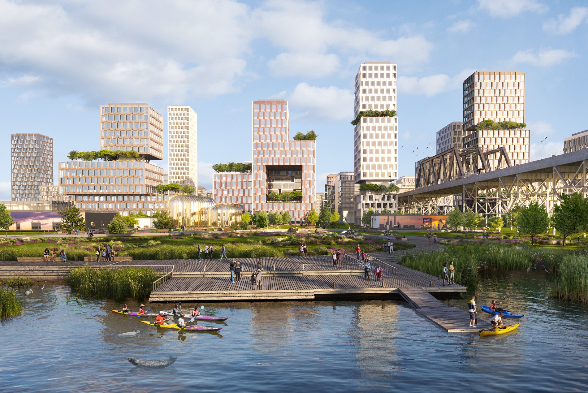
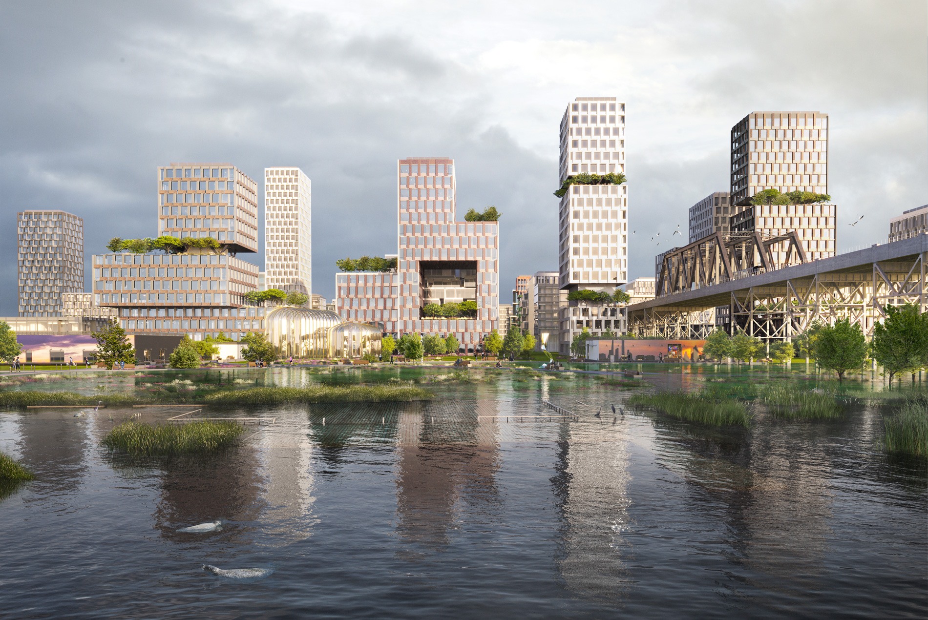
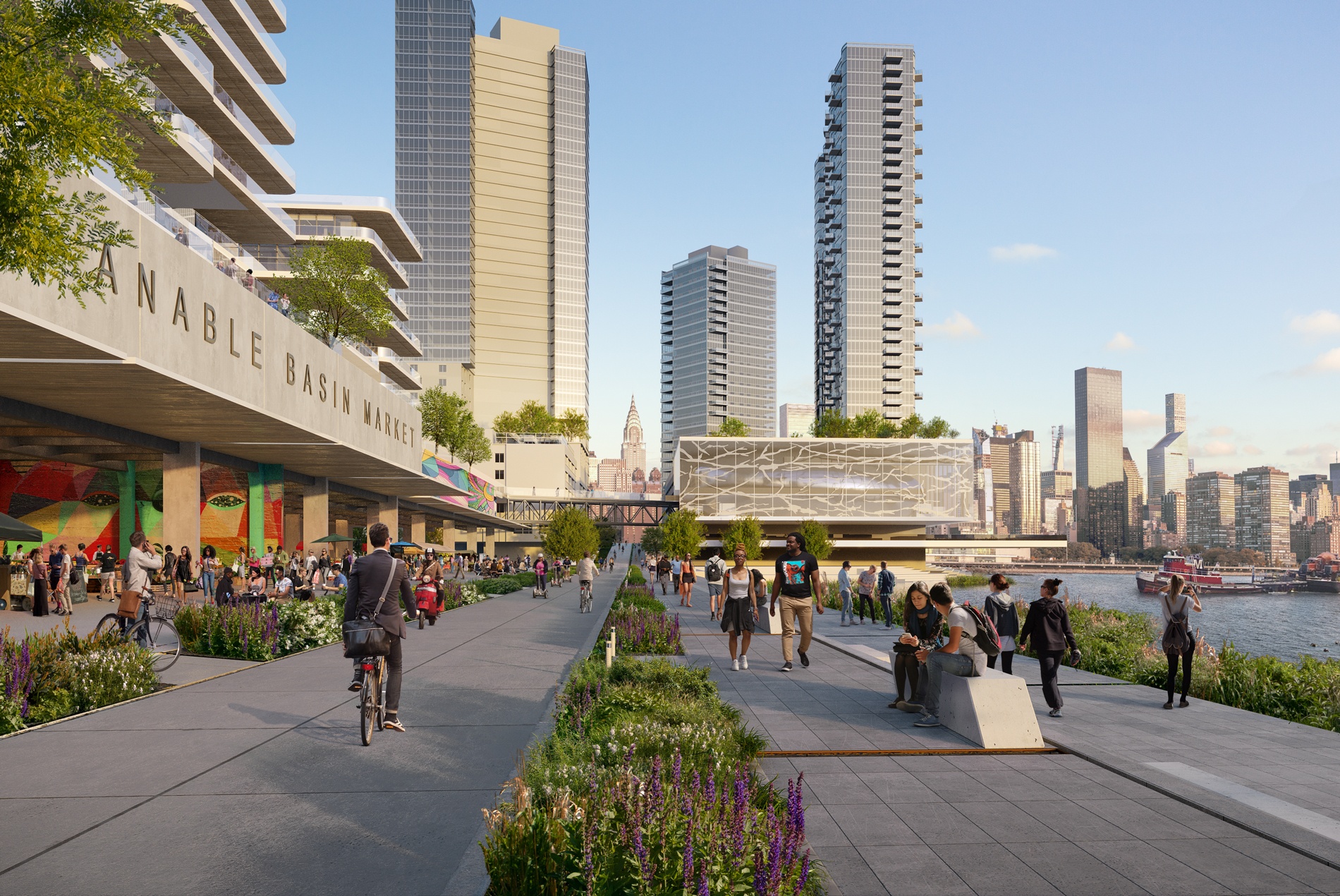
By 2100, the Anable Basin in Hunters Point, Queens, will expand from the rise in the East River, creating opportunities for waterfront development. We envision an activated promenade with a wet-floodproofed market space along its edge. Existing residential towers in the distance could adapt to the new water levels through raised roadways and upper-level bridge connections. Utility corridors would maintain area services.
As barges deliver carbon-capture concrete to build a more sustainable New York, a working waterfront will be more important than ever.
Moving Toward a Healthier Future
NYC 2100 serves as a model study demonstrating how an integrated approach to resilient planning and design can better serve our coastal cities and their neighborhoods, commercial centers and transportation systems. To ensure that we can create the most comprehensive and effective climate change solutions in the future, it’s important to identify both at-risk and opportunity areas now.
Have questions about planning and designing resilient cities? Contact William Kenworthey, HOK’s Planning leader in New York.
Urban design research and mapping created by Betsy Daniel, urban designer at HOK.